Sunday, November 29, 2009

ಕೊಟಿಲಿನ್ಗೆಶ್ವರ - Asia's largest Shiva Linga

The Lord Kotilingeshwara Temple is situated in Kammasandra Village in Kolar district, Karnataka State, India. The temple is about 6 Kms from Kolar Gold Fields also known as KGF. The main deity of this temple is Lord Kotilingeshwara. This Temple was constructed by Swamy Sambha Shiva Murthy.


The temple boasts of having the largest Linga in Asia which stands 108 Feet tall. In front of this uge Linga there is a huge Nandi (Animal mount of Lord Shiva) which is 35 Feet tall. The Nandi is installed over a Platform which is 60 Feet in length, 40 Feet in width and 4 Feet in height.
Inside the Goddess Kanniga Parameswari temple, a Shiva Linga called "Shiva Panchayathi" is installed. The idols of Lord Ganesha, Lord Kumaraswamy, Goddess Parvati and Nandi are arranged around the Linga, Giving an essence that all these Gods are offering their prayers to the Linga. A Water tank is setup close to the Linga. The Water is used by the devotees to offer their prayers by performing Abhisheka to the Linga with utmost devotion and faith.

There are lakhs of Lingas being installed surrounding the temple by the pilgrims since 1980 spread over an area of 13 acres. There are more than 86 Lakhs of Lingas installed as of 2008. The lingas installed vary between 1 feet to 3 feet tall.The temple was started with the intent of installing 1 crore lingas hence the name "KotiLingeshwara". Koti means Crore (10 Million).


Chikka Tirupathi

Chikka means small in Kannada. This temple is supposed to be a miniature version of Tirupati. As per the legend it is supposed to have been built by Agni for Lord Vishnu - for granting him back his tejas (power). But, the temple looks relatively new - especially the gopurams. When we visited it, it was relatively empty. It is around 30-35 kms from Bangalore. It opens at 6:30 AM and closes at 7:30 PM - open through out the day. It is a straight drive from Silk Board Junction. From the outer ring road, join the Sarjapur Road; cross Sarjapura village/town and take a left to NH 207 after Sarjapura village. Keep driving straight on NH207 and you would reach this temple. The drive is pleasant except for a small stretch where we cross the Sarjapura village. After wards, the NH 207 is not very good with a few pot holes every other km till we reach Chikka Tirupathi.

Anthargange
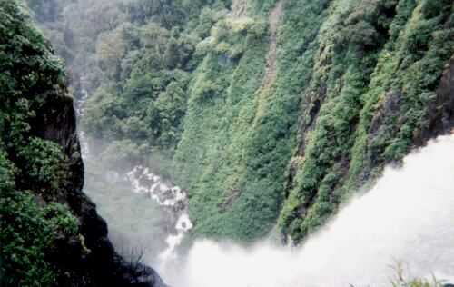
Sixty kilometers from Bangalore, Anthargange is a hill range with huge volcanic rocks and boulders scattered all over. Thorny shrubs cover the hill, while there is dense plantation forest at the base. Flight of steps, halfway the hill leads to an ancient temple. The spring at this temple is claimed to wash off your sins. The forty-five minutes hill climbing will keep you panting for breath and opens up for an extensive and beautiful green plateau on the top.
Anthargange is an ideal location for light trek, rock climbing and camping. Big and small boulders have heaped to form cave like formations offering exhilarating network of cave exploration activity.

ಆಗುಂಬೆ(Agumbe)-Splendid sunset

Agumbe is a village located in the Shimoga district in the state of Karnataka, India. Lying in the Thirthahalli taluk and the Malnad region, Agumbe is among the places in India that receive very heavy rainfall earning it the sobriquet, "Cherrapunji of the South".It is also the home of the Agumbe Rainforest Research Station, the only permanent rainforest research station in India.The renowned herpetologist, Romulus Whitaker called Agumbe the capital of King Cobra. An area near Agumbe has been converted into a protected area for Medicinal Plants to help in their conservation.


Sunset Point
Agumbe has a sunset point which receives lot of visitors. On a clear day, one can see the sun setting over the Arabian Sea though the sea is at quite a distance from Agumbe.


Waterfalls
Kunchikal Falls Kunchikal Falls is the second highest waterfall in India and ranks 116th in the list of highest waterfalls in the world.[4] Its total height is 1493 ft/455 mts. It is formed by the Varahi river.
Barkana Falls Barkana Falls is the 10th highest waterfall in India with a height of 850 ft/259 mts. It is formed by the Seeta River. Onake Abbi Falls This is another waterfall near Agumbe. In the Kannada language, "Onake" means a pounding stick which is used to pound grains in villages. Jogigundi This is a small water fall which is very near to Agumbe, it takes about 10 to 15 min to reach this place.

Agumbe is near the town of Thirthahalli which lies on the National Highway NH-13. From the state capital of Bangalore, Agumbe can be reached by taking NH-4 till Tumkur, then NH-206 till Shimoga and then NH-13 to Thirthahalli (a total distance of about 380 km.). Udupi on the Konkan Railway is the nearest railhead. The nearest airport is the Mangalore International Airport.
It can also be reached from Bangalore via Hassan ~ Belur ~ Chikkamagalore ~ Shringeri ~ Agumbe. As of today, this is the best road to reach there. The road is very good and a lot of places like Belur, Chikkamagaluru and Shringeri can be seen on the way.
Agumbe is the location of the only permanent rainforest research station in India which was established by the herpetologist, Romulus Whitaker.Whitaker chose Agumbe as the location for this station since this was the area where he spotted the King Cobra in the early 1970s.


Malgudi Days
Malgudi Days is a famous television serial which was directed by Shankar Nag and is based on the novels written by R. K. Narayan. Many episodes of this serial were filmed in Agumbe. In 1985, a new set of episodes of Malgudi Days have also been filmed at Agumbe under the direction of Kavitha Lankesh.

ಯಾಣ (Yana)-Adventure destination

Yana is situated in the lush evergreen forests of the Sahyadri Range of Mountains. Yana is in the heart of the dense forests of Western Ghats in Karwar district of Karnataka.It is 25 km from Kumta or can also be approached from Sirsi, which is about 40 km . Sirsi is around 400 Km from Bangalore . From Bangalore you come to Sirsi though Haveri where the major distance of the drive would be on NH4 else from Shimoga route, which is the Bangalore –Honnavar highway.

The Bhairaveshwara Shikhara and the Mohini Shikhara or peaks are the main attraction of Yana. These unique rock formations have made Yana a popular destination for pilgrims, trekkers, and nature lovers.


The Bhairaveshwara peak is about 120 meters and the Mohini peak is about 90 meters from its base. These two peaks are solid composition of black crystalline limestone.As per the mythology, Lord Vishnu (as Mohini) killed an evil demon, Basmasura at this place.

A cave temple dedicated to Lord Shiva is found at the base of the Bhairaveshwara shikhara. Water drips from the projecting rocks over the Shiva linga, and people call this water as Gangodbhava.The idol of Goddess Parvathis is found at the base of the Mohini Shikara.


Many caves are present amongst these rocks and are a very good place for camping.Here we can find many pitch dark caves and can here the errie noises of the bats. The rock formations are terrific .Some of rocks are just sitting tantalizingly at the edges of other rocks and looks as though they may roll any time .But they wont! We explored a bit around these areas


The other attraction is a small waterfall nearby called Vibhuti Falls .

ಗೊಕಾಕ್ (Gokak ) Water Falls-Unique in nature

ಗೊಕಾಕ್ (Gokak ) Water Falls
Gokak Water Falls is in Belgaum District, Karnataka. It is a famous waterfall located at a distance of 6 km from Gokak town and 71 km from Belgaum city. The waterfall is formed when the river Ghataprabha takes a 170 ft leap from over a horseshoe shaped sandstone cliff, spanning a breadth of 177 m.


The falls were discovered as early as 1885 by British explorers who compared it to the Niagara in terms of its height, shape and speed. However, it has not received due attention from the local government. There is a 210 m hanging wooden bridge across the falls, which enables people to cross the river. Only 30 people are allowed at a time on this ancient bridge. The bridge was originally built by the British for the labourers from nearby villages to come to work at the mill located here. Nearby attractions are Gokak Dam and Hydroelectric Power Plant. July-September is the best period to visit the Gokak Falls.
Gokak Falls is a waterfall known for its beauty. It is at a distance of 60 Kms from Belgaum and 10kms from Gokak town. Located right on the main road is a celebrated tourist centre in the district. This falls has a height of about 170 feet. The river Ghataprapha after winding a course of a long route takes a leap of 52 meters, over a rocky bed 170 feet down. The falls is famous for its spread and shape. The rugged valley and the picturesque is what inspires poetry. The dull roar of the falls can be heard much before you reach it. "Except in width and colour of the water, the general features of the fall, its height, shape and rapidity above are much like those of Niagara". The falls are horse-shoe shaped at the crest, with a flood breadth of 177 metres. June to September is the best season to visit Gokak as it bees in full bloom. Electricity was generated here for the first time in the country in 1887. This generating station can be reached on the rope way.

After a long winding course, Ghataprabha river takes a leap of 52 metres over the sand-stone cliff amidst a picturesque gorge of the rugged valley. Except the width and colour of the water, the general features of the fall, its height, shape, and rapidity resemble Niagara Falls on a smaller scale. The waterfall is horse shoe shaped at the crest, with a flood breadth of 177 metres. During rainy season, the thick reddish brown water sweeps far over the brink of the cliff with a dull roar that can be heard from some distance. There is a hanging bridge across the river, measuring about 201 metres. Its height above the rock bed is 14 metres.
July to September is the best season to visit the place. To explore or relax, the natural springs, rivers and hills give the maximum pleasure like only nature can.

ಬೇಲೂರು(Belur) and ಹಳೇಬೀಡು(Halebidu)-Architectural splendour

Belur, Halebidu and Sravanabelagola
Over a thousand years ago a sadhu (ascetic) was attacked by a tiger. Seeing a tribal warrior nearby he called out for help: 'Hoy Sala! Sala!' Without hesitating a man, named Sala, rushed towards the tiger and plunged his spear into its side. Legend credits this courageous man with being the founder of the South Indian dynasty which took its name from the sadhu's cry ('Hoysala') and adopted the symbol of a man killing a tiger as its emblem. The Hoysalas are the least known of South India's kings, whose only enduring legacy after they outgrew their tribal and warlike beginnings were the temples at Belur and Halebid near Hassan, 180 kilometers (112 miles) west of Banglore, and at Somnathpur, 45 kilometers (28 miles) east of Mysore. No other from of Indian art of architecture is as ornate and intricately decorative as theirs, nor, perhaps, as suggestive of languorous sensuality.
BelurIn 1116, King Bittiga repudiated Jainism and returned the Hoysalas to the Hindu fold, renaming himself Vishnuvardhana. In the same year he defeated the mighty Cholas and, to celebrate this victory, ordered a temple erected at Belur, 38 kilometers (24 miles) from Hassan, in honour of Channakesava, an incarnation of Vishnu.
The temple took 103 years to build and in a classic example of the Hoysala style. It rises, like a rococo wedding cake in stone, from a star-shaped plinth, one of the hallmarks of Hoysala building design. From the base upwards, there is an extraordinary wealth of decorative detail; every available inch is crammed with intricate carvings. Line upon line of friezes form bands around the temple, each depicting scenes from Hindu mythology. In one frieze, 650 elephants jostle one another in a continuous line.
All the Hoysala temples are constructed of a kind of soapstone which when freshly quarried is soft and yields easily to the chisel but which hardens after exposure - a characteristic that made it possible from the stonecarvers to achieve a remarkable degree of detail. Many people, however, find the Hoysala style florid and over-decorated.
The tradition of anonymity that conceals the identity of Indian craftsmen is absent at Belur (and Halebid). The name of its architect, Jakanachari, has come down to us, as well as the signatures of his craftsmen.Many of the figures of full-bosomed women depicted at Belur are believed to be portraits of King Vishnuvardhana's queen, Shantala Devi. She was a famous dancer, a woman of great wit and intelligence, and there is a stone portrait of her just inside the temple's eastern entrance. Her husband, the king, stands beside her, mustachioed, bejeweled and justifiable proud.
Halebid
The Halebid temples and palaces that the visitor sees today were once part of the last Hoysala capital, located 16 kilometers (ten miles) east of Belur. In 1310, a Muslim army swept down from Delhi on a rampage, brutally killing its citizens and looting its treasures. Any hope that the city might be rebuilt was crushed forever in 1326 when a second onslaught wrought greater destruction and brought the Hoysala empire to an end.
And yet the remains are magnificent. The main temple is dedicated to Shiva and, as at Belur, was built by King Vishnuvardhana. It conforms, with its star-shaped base, to the pattern of all Hoysala temples but is the most intricately decorated. Only in darkness of the inner sanctum where the stark black lingam, the symbol of Shiva, is still worshipped is there any suggestion of simplicity.

Elephants are believed to denote stability and perhaps it is their sturdy support that has helped the temple to weather the centuries, for an intricately carved line of them winds around the base. Above them are many bands of finely detailed friezes, each with extraordinary examples of superb craftsmanship.

The two-meter (six-foot) devara-palikas, or door guardians of the temple are imposing in height, but what holds the eye is the unbelievable lace-like fineness of the carving. At Halebid the eye can easily become confused by the wealth of ornate carving on the temple and it requires an effort to focus on small details. As at Belur, it is the celestial woman who have the greatest appeal. Saraswati, the Goddess of Learning, is shown dancing and Shiva dances too, as Nataraja, the Lord of the Cosmic Dance. Krishna himself dances, but on the great rearing hood of a demon serpent.

Surprisingly, the temple is unfinished. Stonemasons and sculptors laboured for 86 years and stopped suddenly for reasons unknown.
Sravanabelagola
The huge 17.7-meter- (58-foot-) high monolithic statue of Gommateshvara Sravanabelagola stands on the summit of the 143-meter (470-foot) granite Vindhyagiri Hill. The site was established in the ninth century and remains one of the most important Jain pilgrimage sites in southern India. Every 12 years (next in 1993) the great statue is given a ritual libation. The town is 170 kilometers (106 miles) from Bangalore and 60 kilometers (37 miles) southeast of Hassan.


Saturday, November 28, 2009

ಧರ್ಮಸ್ಥಳ- Dharmastala Manjunateshwara Temple

ಧರ್ಮಸ್ಥಳ- Dharmastala Manjunateshwara Temple


Dharmastala kshetra is located amongst the scenic beauty of the Western Karnataka on the banks of the Nethravathi River.,Beltangady Taluk near Mangalore,under the trusteeship of a Jain familiy, with worship services being performed by Madhva priests. Dharmastala is at a distance of about 75 km from Mangalore.Located in a picturesque settings, it is one of the well visited pilgrimage centers in Karnataka.It has 150 ft tall entrance to the township flanked by numerous choultries on either side. Dharmastala literallymeans a place of Dharma, a path to religion, ritual, duty, righteousness, and alms. It is the embodiment of justice, truthfulness, faith, solace, fulfillment and peace.


Heggade built a temple of Manjunatha Swamy and installed the Kadri’sShiva Linga there. Henceforth, several ceremonies were held together for Manjunatha Swamy, Chandranatha Swamy and the angels.
Dharma Daivas
Festivals:Ganesha festival, Navaratri and Deepavali festivals are celebrated with grandeur at Dharmasthala. The annual festival or carnival called Pattanajae Jatre is held in April every year before the onset of monsoons. People flock from far and near during these times.


Dharmasthala Bahubali Temple
Bahubali Temple enshrines the monolithic statue of Bhagvan Bahubali. The statue epitomizes renunciation, self control and subjugation of ego. The monolithic statue, 39 ft tall, is carved from a single stone with a pedestal 13 ft high.


Laksha Deepothsava
Festival of lights and grand illumination celebrated for five days in the month of Kartika (November – December)
Places to visit in Dharmastala:
Main Temple
* Shri Manjunatheshwara
* Shri Ammanavaru
*Four Dharma Daivas: Kalarahu, Kalarkaayi, Kanyakumari and Kumaraswamy
* Lord Ganapathi* Lord Annappa
Other places to visit at Shree Kshetra Dharmasthala
* Vintage car museum
* Manjusha vastu sangrahalaya (museum)
* Pushpa vatika
* Vasantha Mahal – Cultural Hall

Manjusha MuseumThis Museum near the Temple has a antique collection of swords, armory even old cameras etc. Collection of Temple chariots of various temples of Karnataka are exhibited outside the museum in a shed.
Car Museum: Little away from the main temple, is a car museum with various vintage cars, all in running condition. Among are a Daimler Double Six(1949) owned by King of Mysore Sri Jayachamarejendra Wodeyer. Timmings: 9 am – 1 pm and 2.30 pm – 6 pm.
How to reach:
Dharmasthala is located approximately 300 kms from Bangalore, and is connected by National Highway. It is about 65 Kms from the port town of Mangalore

ಹಂಪೆ hampe

ಹಂಪೆ (Hampi ) - If dreams were made out of stone.

Hampi is an ancient site that once used to be the royal capital of the Vijayanagar Empire. Known as the 'city of ruins', Hampi is a small village in the northern part of Karnataka (From Bangalore it is only 348.9km). Hampi is regarded as one of the most beautiful towns in Karnataka. Located near Hospet, Hampi is easily accessible by regular tourist buses from the major cities and towns of Karnataka. Hampi, the village is upkeeping the religious roots that were sown by the Vijayanagar rulers in the form of its temples.

In the 14th century, Hampi used to make the royal capital and major religious center of the Vijayanagar Empire, one of the greatest empires of the world. Being the carrier of exceptional architectural ruins, Hampi has been listed as the World Heritage Site by UNESCO. Hampi allures myriad number of tourists, owing to its temples, monolithic sculptures and remarkable monuments. The excellent structure of the temples reflects the tint of Hindu style of architecture. Sprawled in the area of about 26 kms, Hampi is akin to an open-air museum of temples. The hoary ambience of this site gets enhanced with its rugged setting. Hampi is also an important pilgrimage center for both the Hindus and the Jains. It is believed that it was the place known as 'Kishkindha' (stated in Ramayana), where Lord Hanuman was born. Situated on the banks of Tungabhadra River, Hampi houses the renowned Virupaksha and Vitthala Temples of India.

Virupaksha TempleVirupaksha Temple is the most famous shrine at Hampi. Also known as Pampapathi Temple, the shrine is completely untouched by the destruction that was seen by many monuments in the 16th century.

Virupaksha Temple has three towers, where the eastern tower rises to 160 feet with nine tiers. The temple traces its origin in the first half of the fifteenth century; however it was refurbished by Krishnadevaraya in the 16th century. The temple is dedicated to Virupaksheshwara (Pampapathi - a form of Lord Shiva). Pampa, who is believed to be the daughter of Brahma, is the divine consort of Virupaksha. There is an ornamented shrine that is dedicated to Bhuvaneswari. There is also a shrine presiding Vidyaranya, the spiritual founder of Vijayanagar. In the inner prakaram, there are shrines and pillars that date back to the 12th century. The temple walls are adorned with manifested images of Shiva and Vishnu.

ಕಳವಾರಳ್ಳಿ ಬೆಟ್ಟ\ಸ್ಕಂದ ಗಿರಿ (Kalavaralli Betta)-THE LAND OF BEAUTY

KALAVARALLI BETTA, SKHANDAGIRI

Skandagiri is a hill next to nandi hills in Chikkaballapur district of karnataka only 70km from Bangalore. Though theres no history or any siginificance attached to this place, it is still a good place frequented by many visitors. The only option for reaching the summit is thorugh a trek and thats what makes this place enjoyable. Watching sun rise,from the top of hill is the beautiful thing you could do here(amidst clouds).


Skandagiri is a hill next to nandi hills in Chikkaballapur district of karnataka. Though theres no history or any siginificance attached to this place, it is still a good place frequented by many visitors. The only option for reaching the summit is thorugh a trek and thats what makes this place enjoyable. Watching sun rise,from the top of hill is the beautiful thing you could do here(amidst clouds).

Skandagiri or Kalavarahalli Betta is 5 kms from Chikkaballapur town(or city now that it is a district headuarters),which is around 60kms from bangalore. I guess reaching this spot will be a lot quicker than reaching the bangalore city from the under construction Bangalore International Airport at Devanahalli. Theres an ashram(papagni math) at the base. You can start your trek from this point. In fact there is another trek route which is a lot steeper than the other. For this route your starting point will be a bit farther from the ashram.)

Journey through Karnataka

Explore and discover!!!

Journey through Karnataka is a feeling of divinity with nature. Fragrance of sandal and agarbathis, flowers such as Jasmine famous as Mysore Mallige, Sunflower, Rose and aroma of coffee beans towards south are all make you heavenly feeling.

The world famous Jog falls is really wonderful. Its panoramic view makes you so delightful.

The central and southern area of the Karnataka is known for its medieval historic architecture, such as the stone temples located in Belur and Halebeedu, the famous Mysore Palace of Sri krishnaraja Wodayar-Maharaja and Srirangapattana of Tippu sulatan and spiritual famous place Shravanabelagola is an important Jain pilgrimage center, visited by thousands of pilgrims every year. Hampi, the outstanding land, one can still take glimpse of the mind-blowing Vijayanagar - one of the largest empires in the history of India - in its ruins. The Vijayanagar Kings were great patrons of Art & Architecture as evident by the vast ruins of Hampi.

Coastal areas of Karnataka along Arabian Sea are so beautiful. The extensive stretch of golden sand, swaying Palm trees, clear blue sky and the gurgle of the sea draws several tourists to this spot. It is a popular picnic spot due to the amazing beauty and serene surrounding of its virgin beach. The main beautiful beaches of Karnataka are: Devbagh Beach, Murudeshwar Beach, Malpe Beach, Maravanthe beach and Karwar beach.

Enjoy the fairs and festivals of Karnataka that celebrate life in all its infinite variety. Most of them are exclusive to the state and reverberate with colur and gaiety. Every hamlet and village, every town and city has its own calendar of events to be celebrated with Karnatic Classical music and dance and culture.

The Ideal Travel Destinations are as follows:

In Bangalore: Lalbagh, Cubbon Park, Palace of Tipu Sultan, Bull Temple, Museum, Halasur Lake, Someshwara Temple Halasur, Iskcon Temple, Shiva Mandir Airport Road, Bannerghatta National Park, Meenakshi & Sundareshwara Temple Bannerghatta Road.

Around Bangalore: Nandi Hills, Thalkadu, Big Banyan Tree, (Ramohalli) Shivaganga, Mekedatu (Goat's Leap), Ghati Subramanya, Devarayanadurga, Muthyala Maduvu (Pearl Valley), Savanadurga, Shivanasamudra.

Other places in Karnataka:

Sl No Place Importance Distance from Bangalore
1 Mysore The Mysore Palace, Art Gallery,Philomena's Church, KRS Dam,Brindavan Gardens, Mysore Zoo -- 140 Kms
2 Sri Rangapatanna historic place, Cauvery river, Daria Doulat Bagh museum-- 123 Kms
3 Horanadu Kalasa Famous Adishaktyatmaka Shri Annapoorneshwari Temple, Horanaadu
Shri Kalasheshwara Temple, Kalasa --330 Kms
4 Hampi historic place of Vijayanagar empire, Tungabhadra Dam.- 353 Kms
5 Agumbe Hill station -370 Kms
6 Belur Temple architecture - 222 Kms
7 Halebid Hoysaleswara Temple - 216 Kms
8 Kolar Gold Mines - 80 Kms
9 Chikmagalur Baba Budan Mountains, Sanctuary, Kemmanagundi, Kudremukh, Sringeri 10 Manipal Educational institutes
11 Shravanabelagola Pilgrim center, statue of Lord Bahubali.- 146 Kms
12 Bellary Granite Mines
13 Talakad Bank of the river Cauvery, Vaidyeshwara Temple - 132 Kms
14 Gokak Gokak Water Falls
15 Ranganthittu Bird sanctuary - 125 Kms
16 Karkala Gomateshwara statue
17 Nagarhole National Park -236 Kms
18 Kollur Sri Mookambika Temple
19 Bandipur Forest, Sanctuary- 217 Kms
20 Bhadra Badhra Sanctuary - 257 Kms
21 Hogenakal Picnic spot -140 Kms
22 Kemmanagundi Hill station, Height of 1434 meters - 380 Kms
23 Yelemadalu Plantations
24 Mangalore Beaches and scenic spots -357 Kms
25 Jog Waterfalls, Sharavathi River - 378 Kms
26 Madikeri Hill station, Abbey Falls, Talacauvery - 252 Kms
27 Bijapur Historical place, Gol Gumbaz, tomb of Mohammed Adil Shah. echo chamber -550 Kms
28 Sringeri Pilgrim center, Sri Adi Shankaracharya peeta, River Tunga

29 Dharmasthala Sri Manjunathaswamy Temple, Chandranatha Swamy Basadi, Statue of Shri Bhagawan Bahubali, Car Meseum, River Nethravathi.- 325 Kms
30 Malpe Beach -(6 Kms from Udupi)
31 Murudeshwar Historical place, Sri Murudeshwar Temple, Beach

32 Gokarna Sri Mahabaleshwara Temple, Sri Ganapati Temple, Sri Tamra Gauri Temple, Beach
33 Karwar Sea side, Beaches, Venkatarama Temple - 520 Kms
34 Aihole Picturesque village, the cradle of Indian architecture -483 Kms
35 Kukke Subrahmanya Sri Subrahmanya Temple, Samputa Narasimha Temple, Uma Maheshwara Temple, Adi Subrahmanya, Kashi Katte Ganapathi, River Kumaradhaara, Hosaligammana Gudi
36 Kateel Kateel Sri Durga Parameshwari Temple, River Nandini

Friday, November 27, 2009

Gandhada Gudi Karnataka

Jai Karnataka

Karnataka (Kannada: ಕರ್ನಾಟಕ, pronounced [kəɾˈnɑːʈəkɑː] is a state in the southern part of India. It was created on November 1, 1956, with the passing of the States Reorganisation Act. Originally known as the State of Mysore, it was renamed Karnataka in 1973.

Karnataka is bordered by the Arabian Sea to the west, Goa to the northwest, Maharashtra to the north, Andhra Pradesh to the east, Tamil Nadu to the southeast, and Kerala to the southwest. The state covers an area of 74,122 sq mi (191,976 km²), or 5.83% of the total geographical area of India. It is the eighth largest Indian state by area, the ninth largest by population and comprises 29 districts. Kannada is the official and most widely spoken language.

Though several etymologies have been suggested for the name Karnataka, the generally accepted one is that Karnataka is derived from the Kannada words karu and nādu, meaning elevated land. Karu nadu may also be read as Karu (black) and nadu (region), as a reference to the black cotton soil found in the Bayaluseeme region of Karnataka. The British used the word Carnatic (sometimes Karnatak) to describe both sides of peninsular India, south of the Krishna River.

With an antiquity that dates to the paleolithic, Karnataka has also been home to some of the most powerful empires of ancient and medieval India. The philosophers and musical bards patronised by these empires launched socio-religious and literary movements which have endured to the present day. Karnataka has contributed significantly to both forms of Indian classical music, the Carnatic (Karnataka Music) and Hindustani traditions. Writers in the Kannada language have received the most number of Jnanpith awards in India. Bangalore is the capital city of the state and is at the forefront of the rapid economic and technological development that India is experiencing